I read this for the Fall 2025 Science Fiction and Fantasy course I took at the U of MN.
I was not enthralled by this book. In fact, at about the halfway point, I misplaced it and did not finish it. I still haven’t found it, though no doubt it will turn up somewhere.
[Spoiler follows]
The City & the City is a competent murder mystery, but with the fantastical twist that the City is a place where an analog of the City in a parallel universe is partially visible and sometimes accessible. Inhabitants of the City have trained themselves to not see traces of the parallel city – if they give it too much attention something will happen — a mysterious force or set of police or something – will appear and remove everyone who was implicated or involved in noticing/acting in the parallel world. Yet, in spite of this, or perhaps because of it, there is an officially managed gateway between the two versions of the City, though much bureaucracy is involved in moving from one side to another.
The murder which drives the plot — well, at least the plot for the half of the book I’ve read — appears to have been committed in the parallel city, and then the body deposited in the other city. This brings police from both ‘sides’ together to investigate what happened. That had just begun to happen when I lost the book…
While it’s an interesting set up, and while the writing is well done, I found (as is often the case) that I don’t really care for the protagonists. There’s one chief detective (or maybe he’s an inspector) and he’s gotten a younger colleague involved to assist him — but he seems to have no life other than work, and no real friends. The most emotional life he shows has to do with his colleague, but even there it is pretty sparse (though perhaps something richer will develop as the book proceeds).
While I finish the book when I find it again? I’m not sure… I don’t find that I care very much or feel very curious.
The Saint of Bright Doors, Vajra Chandrasekara, 2023
This is an acclaimed science fiction book that has gathered both critical and popular praise. I read it a couple of years ago — I try to read the ‘best of the year’ books in SF – and it didn’t engage me, although I did manage to finish it. I am now reading it a second time, as part of a Science Fiction and Fantasy course I’m taking at the U, and am going to try harder to appreciate it; or at least to understand what others appreciate in it. And perhaps also reflect on aspects of it that prevent me from appreciating it.
At this point I’ve just started the re-read it. I am noticing some very nice turns of phrase. I also notice that the protagonist begins as, in a sense, an abused child who is being trained to do terrible things by a mother who sees him only as a tool. I’m not really noticing much in the way of love or affection or humor among any of the characters.
I am told this is a classic papper. Here are some notes / excerpts:
“Basaltic magma is derived by incongruent partial melting of mantle peridotite, favoured in tectonic settings (e.g. hotspots and rifts) where mantle rock rises adiabatically to relatively shallow levels, or in subduction-zone settings where volatiles decrease the melting temperature of mantle rock.”
Important magma parameters (pretty uniform for basaltic volcanos)
Magma density relative to lithosphere density — helps deter- mine the positions of magma chambers and intrusions;
Viscosity and yield strength determine the geometry and structures of lava flows and intrusions;
Gas content + viscosity + rheology controls the explosive violence of eruptions by determining the ease with which gases escape from magmas.
Parameters responsible for diversity: magma-supply rate and involvement of non- magmatic water.
”Basaltic systems have a source in the mantle from which magma ascends, mainly because of its positive buoyancy but sometimes aided by tectonic forces, toward the surface. They have one or more conduits by which the magma ascends. Polygenetic volcano systems generally possess a high-level magma chamber, situated at a neutral buoyancy level, which stores magma and modulates its delivery to the volcano and to sub-volcanic intrusions. Deep storage reservoirs may also exist.”
Types of volcanos
Shield volcanos
Stratovolcanos
Central Volanos.
Monogenetic volcanoes. These consist of clusters of scattered and mostly small (> 2 km3) volcanoes, each generated by a single eruption. Most commonly a volcano con- sists of a cinder cone associated with outflows of aa lava, but some are lava shields of scutulum- type (e.g. Rangitoto Island, Auckland, and Xitle in M…, and many that occur near the coast or close to lakes are phreatomagmatic tuff-rings or maars.
Flood basalt fields consist of monogenetic volcanoes erupted from widely scattered vents, but their lava flows cover wider areas, overlap or are superposed to form parallel-stratified successions, and have much greater volumes. Giant flood-basalt fields are distributed through geological time at average intervals of 32 Ma (Rampino & Stothers 1988), and each one formed at the time of inception of a hotspot, on arrival of an ascending mantle plume at the asthenosphere/litho- sphere boundary.
Volcano Collapse due to instable foundations, layers of pyroclastic or hydrothermally-altered material, intrusive dykes, local updomings in central volcanoes, severe marine erosion.
Polygenetic vs. monogenetic. “In the polygenetic volcano systems, magma batches ascend sufficiently frequently along the same conduit that the conduit walls are maintained in a hot condition and provide magma with a thermally and mechanically very favour- able pathway toward the surface. In the monogenetic and flood basalt systems magma batches ascend at such long time inter- vals that the pathway taken by one batch has effectivelycooled by the time that the next batch is ready to ascend.”
Fissures / Rift systems. ‘Most basaltic eruptions occur from fissures, and virtually all basaltic volcano systems have eruptive fissures. Fissures are opened very easily by the hydraulic jacking action of magma, and are the ‘natural’ underground conveyance for low- viscosity magma (Emerman & Marrett 1990). They commonly extend for tens of kilometres and are typically concentrated into rift zones. Magma solidified in fissures forms dykes. Dykes have a high survival potential, and in deeply eroded areas may be virtually all that survives of the volcanic system.
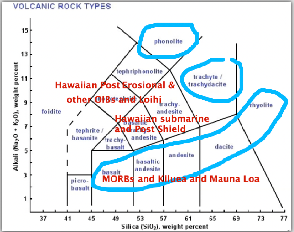
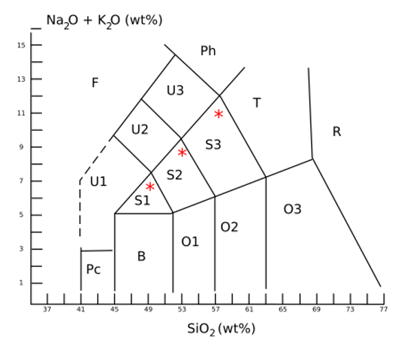
F (Foidite)—When possible, classify/name according to the dominant feldspathoid. Melilitites also plot in this area and can be distinguished by additional chemical criteria.
(*)Sodic as used above means that Na2O – 2 is greater than K2O, and potassic that Na2O – 2 is less than K2O. Yet other names have been applied to rocks particularly rich in either sodium or potassium—as are ultrapotassic igneous rocks.
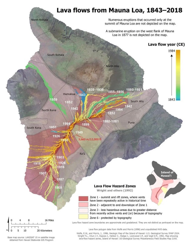
Lava flows from Mauna Loa
Palagonite
About Palagonite
Palagonite is an alteration product formed from basaltic glass (tachylite); concentric bands of it often surround kernels of unaltered tachylite, and are so soft that they are easily cut with a knife. In the palagonite the minerals are also decomposed and are represented only by pseudomorphs.
Palagonite soil is a light yellow-orange dust, comprising a mixture of particles ranging down to sub-micrometer sizes, usually found mixed with larger fragments of lava. The color is indicative of the presence of iron in the +3 oxidation state, embedded in an amorphous matrix.
Palagonite tuff is a tuff composed of sideromelane fragments and coarser pieces of basaltic rock, embedded in a palagonite matrix. A composite of sideromelane aggregate in palagonite matrix is called hyaloclastite.
Formation of Palagonite
Phreatomagmatic. Palagonite can be formed from the interaction between water and basalt melt. The water flashes to steam on contact with the hot lava and the small fragments of lava react with the steam to form the light-colored palagonite tuff cones common in areas of basaltic eruptions in contact with water.
Weathering. Palagonite can also be formed by a slower weathering of lava into palagonite, resulting in a thin, yellow-orange rind on the surface of the rock. The process of conversion of lava to palagonite is called palagonitization.
Tachylite
About Tachylite (tachylyte)
Tachylite (from ταχύς, meaning “swift”) is a form of basaltic volcanic glass formed by the rapid cooling of molten basalt. It is a type of mafic igneous rock that is decomposable by acids and readily fusible. The color is a black or dark-brown, and it has a greasy-looking, resinous luster. It is often vesicular and sometime spherulitic. Small pheoncrysts of feldspar or olivine are sometimes visible. Fresh tachylite glass often contains lozenge-shaped crystals of plagioclase feldspar and small prisms of augite and olivine, but all these minerals occur mainly as microlites or as skeletal growths with sharply-pointed corners or ramifying processes.
All tachylites weather easily and become red to brown as their iron oxidizes.
Formation
Three modes of occurrence characterize this rock. In all cases they are found under conditions which imply rapid cooling, but they are much less common than acid obsidians. (Alkaline rocks have a stronger tendency to crystallize (i.e. not form glass), in part because they are more liquid and the molecules have more freedom to arrange themselves in crystalline order.)
Scoria
The fine scoria (aka cinders) thrown out by basaltic volcanoes are often spongy masses of tachylite with only a few larger crystals or phenocrysts imbedded in black glass. Basic pumices of this kind are exceedingly widespread on the bottom of the sea, either dispersed in the pelagic red clay and other deposits or forming layers coated with oxides of manganese precipitated on them from the sea water. These tachylite fragments, which are usually much decomposed by the oxidation and hydration of their ferrous compounds, have taken on a dark red color (scoria is from σκωρία, skōria, Greek for rust.); this altered basic glass is known as “palagonite.” [see above]
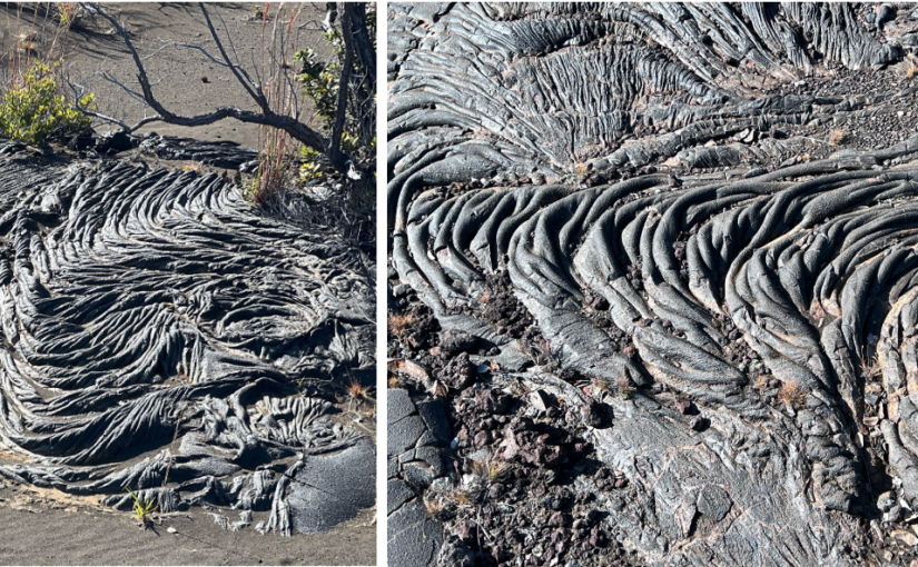
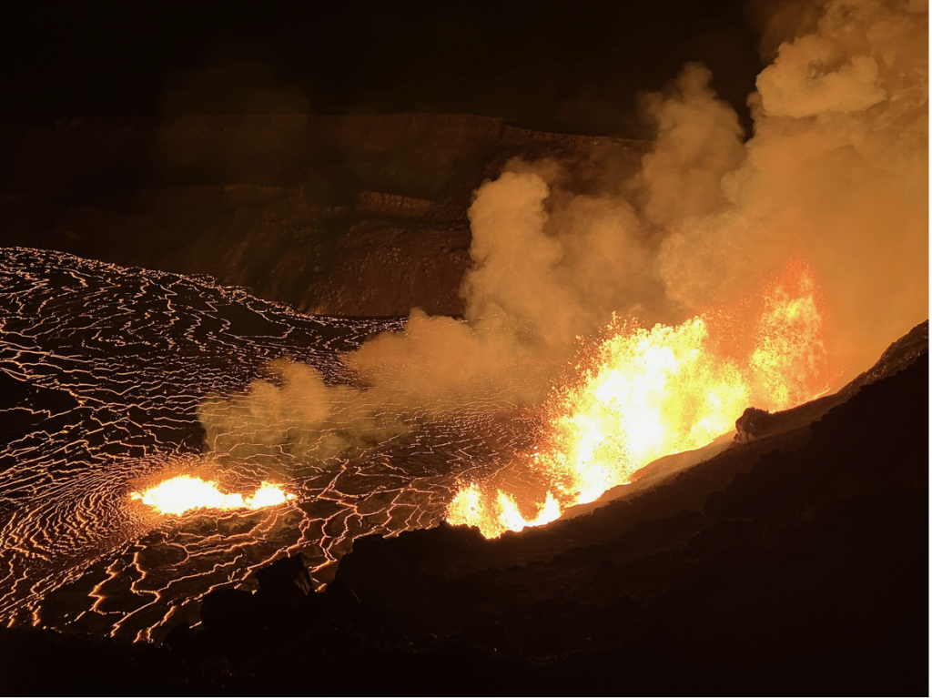
Lava flows
In the Hawaiian Islands volcanoes have poured out vast floods of black basalt, containing feldspar, augite, olivine, and iron ores in a black glassy base. They are highly liquid when discharged, and the rapid cooling that ensues on their emergence to the air prevents crystallization taking place completely. Many of them are spongy or vesicular, and their upper surfaces are often exceedingly rough and jagged, while at other times they assume rounded wave-like forms on solidification. Great caves are found where the crust has solidified and the liquid interior has subsequently flowed away, and stalactites and stalagmites of black tachylite adorn the roofs and floors. On section these growths show usually a central cavity enclosed by walls of dark brown glass in which skeletons and microliths of augite, olivine and feldspar lie embedded
Dikes and Sills
A third mode of occurrence of tachylite is as margins and thin offshoots of dikes or sills of basalt and diabase. They are often only a fraction of an inch in thickness, resembling a thin layer of pitch or tar on the edge of a crystalline diabase dike, but veins several inches thick are sometimes found. In these situations tachylite is rarely vesicular, but often shows pronounced fluxion banding* accentuated by the presence of rows of spherulites that are visible as dark brown rounded spots. The spherulites have a distinct radiate structure and sometimes exhibit zones of varying color. The non-spherulitic glassy portion is sometimes perlitic, and these rocks are always brittle. Common crystals are olivine, augite and feldspar, with swarms of minute dusty black grains of magnetite. At the extreme edges the glass is often perfectly free from crystalline products, but it merges rapidly into the ordinary crystalline diabase, which in a very short distance may contain no vitreous base whatever. The spherulites may form the greater part of the mass, they may be a quarter of an inch in diameter and are occasionally much larger than this.
Flow banding is caused by friction of the viscous magma that is in contact with a solid rock interface, usually the wall rock to an intrusive chamber or the earth’s surface.
The friction and viscosity of the magma causes phenocrysts and xenoliths within the magma or lava to slow down near the interface and become trapped in a viscous layer. This forms laminar flow, which manifests as a banded, streaky appearance.
Flow banding also results from the process of fractional crystallization that occurs by convection if the crystals that are caught in the flow-banded margins are removed from the melt. This can change the composition of the melt in large intrusions, leading to differentiation.
From GPT:
Fluxion banding results from shear forces within a moving magma body. This can happen in several ways:
1. Differential Flow in Lava. As lava moves, its viscosity varies due to cooling and crystallization. The outer layers, which cool faster, may develop a plastic or solid crust, while the inner material remains fluid. This difference in viscosity causes layers of magma to stretch and deform, forming elongated bands.
2. Crystal Sorting and Alignment. “ As magma flows, mineral crystals within it may become aligned due to shear stress. This is common in silicic lavas like rhyolite and dacite, where feldspar and quartz can form parallel bands.
3. Magma Mixing and Compositional Banding. If two magmas of different compositions mix, they may not completely homogenize, leading to streaks of contrasting compositions that appear as bands.
4. Intrusive Settings. In some plutonic rocks, fluxion banding may form as a result of late-stage magmatic flow, where crystals and melts segregate due to convection or deformation.
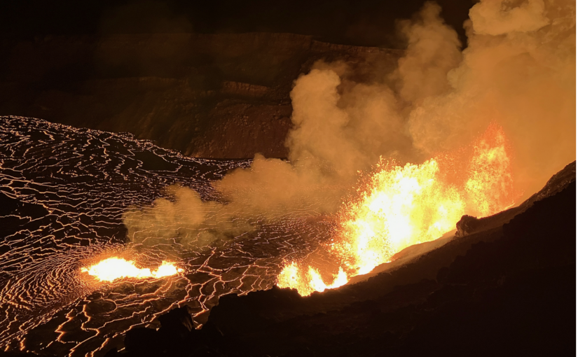
Kilauea: Dynamics of eruptions; Magma types
over the last 4 decades Kilauea has been very active, erupting both from Haumaumau crater on its summit and various rifts on its east side.
in 1983 Kilauea longest and most voluminous outpouring of lava from Kīlauea’s East Rift Zone in over 500 years. It resulted in the creation of the Pu‘u ‘Ō‘ō cone and extensive lava flows that covered significant areas, destroyed numerous structures, and added new land to the island.
Kilauea erupted on 4 May 2018 — it was an east rift zone eruption following the collapse of the Pu’u O’o vent. The rift eruption was driven by collapse of the central (shallow) magma chambers
The 2018 rift eruption had at least three different magmas:
a highly evolved cool (1110°) viscous lava presumably from sources in the rift system [May 3-9]
a less evolved hot (1130°) more fluid lava [May 17-18…]
a very hot (1145°) magma lacking the cargo of low temperature crystals of the previous lavas, but with olvine with high levels of MgO indicating magma > 1250° somewhere in the feeder system
“The first two were the chemically evolved basalt of the initial fissures and the highly viscous andesite. Both are volumetrically minor sources that represent distinct pockets of old residual magma from Kīlauea’s east rift zone that evolved for more than 55 years, cooling and crystallizing at depth. The third and volumetrically more substantial source was less-evolved and hotter basalt of fissure 8. This source was similar in composition to the magma erupted at Kīlauea in the years before 2018 and was ultimately derived from the summit region. Draining and collapse of the summit by this voluminous eruption may have stirred up deeper, hotter parts of the summit magma system and sent mixed magma down the rift..”
Things I’ve learned re eruption dynamics and magmas
Not all lava from Hawaiian volcanoes is basaltic
Even that that is basaltic, changes in composition; each eruption features at least one, and often several, unique lava compositions.
Magma chambers are not homogeneous; this is presumably even more true of rift systems, where greater cooling can generate mushes of crystals
The 2018 Kilauea rift eruptions were driven by collapse of summit magma chambers.
The 2018 Kilauea rift eruption exhibited periodicity of 2-3 days (surges that began within minutes of caldera collapses 40 K upslope) and 5-10 minutes (pulses driven by local outgassing changes )
The dynamics of an eruption can be mapped into several stages
Lateral injection of magma into a rift zone (which forms, in Hawaii, due to volcano flanks sliding into ocean) leads to initial eruption
Pressure in the rift system leads to its elaboration – advancing dikes may capture pockets of highly evolved magma with mushes of low temperature crystals.
Magma injection into rifts, if large enough, can trigger slip on caldera ring faults
Ring fault slippage can add pressure to rift system and drive eruptive behavior at the rift
The central magma chamber appears to be vertically zoned. Initial eruptions of the rift zone (after flushing out pockets of magma that have evolved in the rifts) are composed of younger magmas from lower in the chamber; summit eruptions are fed by older, more evolved magma, higher up in the chamber.
The 2018 Kilauea eruption produced lava at volumes of 100 meters3/sec
Stages of Hawaiian volcanoes: pre-shield (alkalic basalt & basanite); shield (thoelitic basalt derived from both shallow plumbing system and deep plumbing system adjacent to mantle); post-shield (alkalic basalt from deep plumbing system adjacent to mantle (shallow plumbing has crystalized)); post erosional/rejuvenated (alkalic basalt, basanite & nephelinite from ???)
Order and nature of basaltic mineral & crystals
Common minerals that crystallize from basaltic magma, ordered by the temperatures at which they typically form:
*Olivine (Ca2(Mg,Fe)4O4): This is one of the first minerals to crystallize at the highest temperatures, typically around 1,200°C to 1,300°C. Olivine is rich in magnesium and iron and is often found in the earliest stages of crystallization in basaltic magmas. *Olivine crystals are olive-green to yellow-green color. It often has a glassy or vitreous luster, and the crystals can be angular or rounded, with a granular texture when present in volcanic rocks. When olivine crystals are large enough, they often appear as transparent or translucent, sometimes with visible crystal faces, which are usually in a near-rectangular shape. When olivine is exposed to oxidation, especially under conditions of high temperatures or in the presence of oxygen, it can alter to a yellowish or brownish hue, sometimes developing a reddish or rusty tint due to the formation of iron oxide minerals.
*Pyroxene (e.g., augite, diopside): Pyroxenes crystallize at slightly lower temperatures, generally around 1,100°C to 1,200°C. These minerals are composed of chains of tetrahedra and are rich in iron and magnesium. *Augite crystals are dark green to black, often with a shiny, almost metallic luster. It crystallizes in short prismatic crystals, which are often rectangular or blocky in shape. Augite crystals are typically larger than many other basaltic minerals and can be quite visible in coarse-grained basalts. Augite, being rich in iron, may undergo partial oxidation upon exposure to the atmosphere. The oxidation often causes a darkening of the color to a more brownish or reddish tint, though it rarely forms the rusty, reddish color seen in olivine. Augite may also exhibit a duller or more matte luster when oxidized. *Diopside is another pyroxene mineral, typically appearing as light green to pale green, although it can also be colorless or pale yellow. It forms prismatic crystals that are often transparent or translucent. Diopside crystals have a glassy or vitreous luster and typically display distinct striations or fine parallel lines on their crystal faces.
*Plagioclase feldspar (labradorite, anorthite): Plagioclase forms between 1,000°C and 1,100°C in basaltic magmas. This mineral can range from calcium-rich (anorthite) to sodium-rich (albite) compositions, with the more calcium-rich varieties crystallizing at higher temperatures. * Plagioclase crystals vary from white to gray, and often have a glassy luster. They are typically tabular or blocky in shape and can show distinctive twin planes (known as albite twinning).
Magnetite (Fe3O4): Magnetite crystallizes at around 1,000°C to 1,100°C and often forms alongside other iron-rich minerals. It is a common accessory mineral in basaltic magmas. * Crystals not typically visible in lavas
Ilmenite (FeTiO3): Ilmenite forms at slightly lower temperatures, typically around 900°C to 1,000°C. It is a titanium-iron oxide mineral and often occurs in basaltic lavas. * Crystals not typically visible in lavas
Spinel (MgAl2O4): Spinel crystallizes at lower temperatures, usually around 900°C. It is a common accessory mineral in basaltic rocks, often forming in the lower temperature range of basaltic crystallization. * Crystals not typically visible in lavas
These minerals crystallize according to Bowen’s reaction series, where early-formed minerals (like olivine and pyroxene) are typically more magnesium- and iron-rich, while later-formed minerals (like plagioclase and spinel) are more silica-rich due to depletion of Mg and Fe.
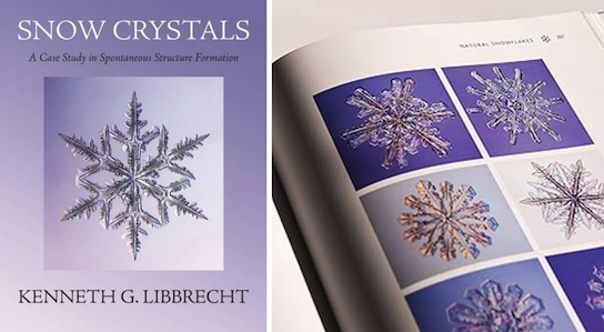
Snow Crystals: A Case Study of Spontaneous Structure Formation, Kenneth Libbrecht, 2022
This is Libbrecht’s magnum opus, at least on snow; this goes deep into the science. …and I love that he has ordered the references by date, so you can see the history of the science leading up to Libbrecht’s work.
I’m taking an introductory Shakespeare course at the U of Minnesota this fall.
Week 1: Intro & Life of Shakespeare, 1
The course looks very promising. The professor, Katherine Schiel, is a Shakespeare scholar and in particular researchers the life of Shakespeare’s wife. The course focuses on literature (rather than TV and move adaptations), and the syllabus shows that we will cover eight of Shakespeare’s works, including the sonnets. I was also struck by how much more talkative and friendly the other students in the course are – both in engaging in in-class discussion, and in engaging with me.
These are more general notes; I also notes on each play read that can be found from the “About this site” page.
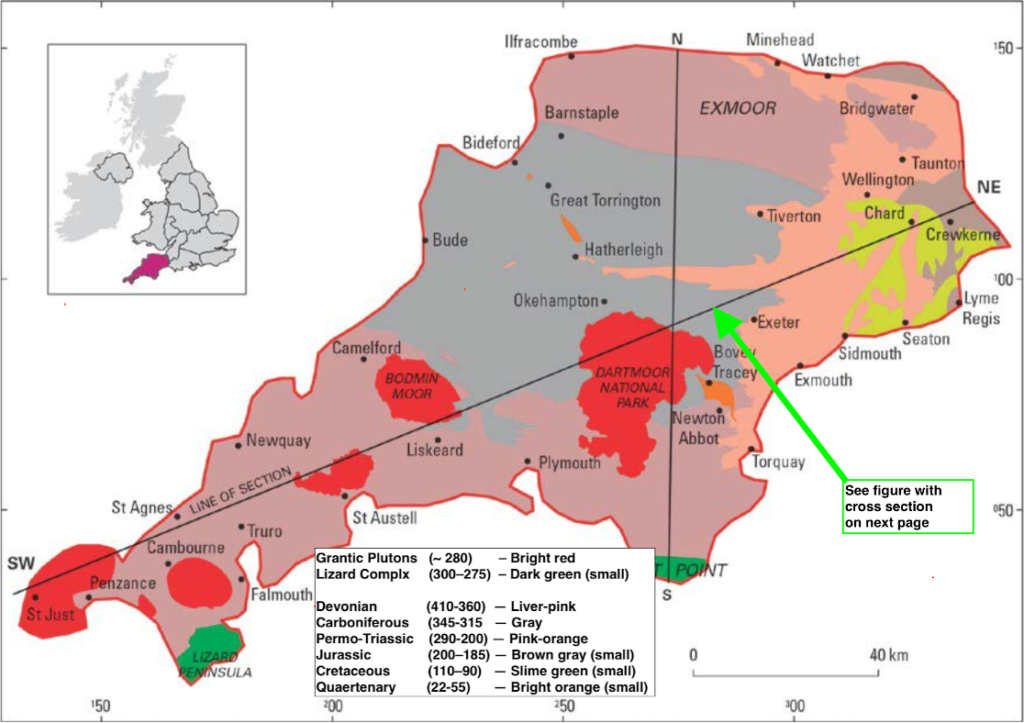
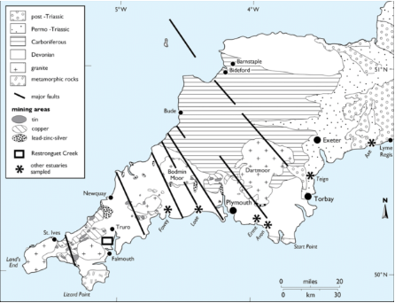
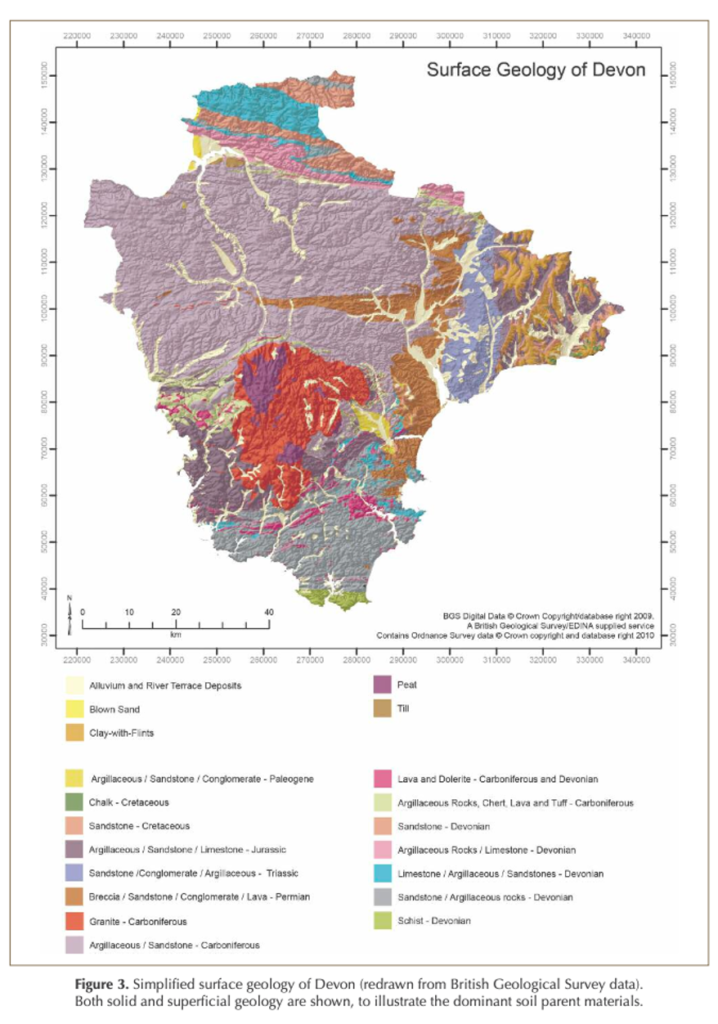
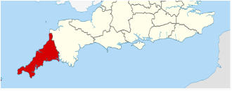
[Mostly sourced from BGS Regional Summaries: SW England; some synthesized from across document]Southwest England is characterized by Devonian and Carboniferous (420 – 299 Ma) sedimentary rocks like shales, sandstones, and limestones that were folded and faulted during the Variscan orogeny (which contributed to the formation of Pangea) during the same period. The sedimentary rocks result from a series of shallow, largely marine environments; thus fossils are abundant. There are also intrusions of granitic rocks (~ 280 Ma), and some very recent sedimentary beds resulting from glacial melting over the last 2 Ma.
Rock Types: Sedimentary, Metamorphic, Igneous
There are three predominant types of rock in southwest England: ‘recent’ sedimentary rocks (25-300Ma ); older sedimentary rocks (315-410 Ma); and plutons connected to the Cornubian batholith.
The recent sedimentary rocks were laid down during more tropical climatic periods when the area was close to the equator. They represent environments that were marine (primarily shallow), fluvial, or desert. Many of them have abundant fossils of marine and terrestrial life.
The older sedimentary rocks represent predominantly marine environments (shallow and deep). They were subject to tectonic forces about 310 Ma, and are consequently folded and subjected to high temperature (and sometimes high pressure) metamorphism.
The igneous rocks are granite, and the plutons, including those at Dartmoor and St Austell) are all connected to the Cornubian batholith. The granite intruded into the overlaying sedimentary rocks around 280 Ma. See red areas of the figure below; also see the section on “The Granite of Dartmoor.” This lead to regional and contact metamorphism, as well as subsequent hydrothermal alteration.
These sedimentary rocks have been subject to low grade regional metamorphism and, over extensive areas, and have also experienced high grade contact metamorphism, metasomatism and mineralisation associated with intrusion of the Cornubian batholith.
The majority of the meta-sediments are pelites[metamorphosed mudstones] or greywackes[metamorphosed sandstones] and are of Devonian age, although in North Devon a large synclinal structure preserves Carboniferous sediments of similar facies.
[Summary] Paleozoic Timeline with focus on Southwest England
541 to 485 Ma (Cambrian): Cool climate and shallow seas. Trilobites, Graptolites, and Molluscs appear.
485 to 444 Ma (Ordovician): Still cool; Sea separating what is now North America/Scotland & England/Wales begins to close.
444 to 419 Ma (Silurian): Climate warms to tropical; Britain covered by shallow sea. Corals, brachiopods, trilobites, graptolites.
419 to 359 Ma (Devonian): Semi-arid, with shallow seas and land. “Old Red Sandstone” deposition. Variscian orogeny begins.
The rock types mentioned in the previous section were subject to intense deformation during the Variscan Orogeny (late Carboniferous to early Permian) and the coastal sections (particularly in the vicinity of Bude [northern Cornwall]) provide many of the classical examples of fold and thrust geometries that are seen in structural geology textbooks.
The deformation has a single fold phase providing the dominant structural style. The intrusion of granites occurred towards the end of the Variscan events, and cooling and alteration of the granites and their country rock and the associated mineralisation continued for a very considerable time after emplacement of the granites.
In the Cambrian Period, England and Wales lay near the south pole and experienced a cold climate. They were separate from Scotland, which was joined to North America. A shallow sea covered much of the area and animals such as trilobites, graptolites and molluscs first appeared.
Apparently there are Cambrian rocks in Wales – as Cambria is another name for Wales.
In the Ordovician Period, Britain lay south of the equator and had a cool climate. Seas covered Britain and there was dramatic volcanic activity as the ocean separating England and Wales from Scotland started to close.
In the Silurian Period, Britain lay south of the equator with a tropical to subtropical climate. A sea covered Britain that was shallower in the south (limestones) and deeper in the north (sandstones and mudstones). Silurian fossils include corals, brachiopods, trilobites and graptolites.
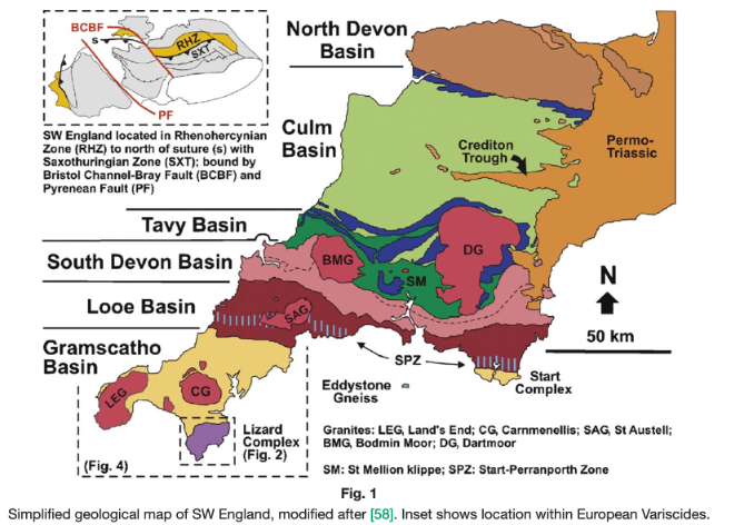
~ 435 Ma: SW England is located north of Rheic Ocean
In the Devonian Period, Britain lay south of the equator and had a semi-arid climate. Marine limestones, sandstone and mudstones were developed in the south-west. Elsewhere sandstones were deposited by rivers on the coastal plain (sometimes known as the ‘Old Red Sandstone’). Fossils include fish and the first higher plants.
The Variscan orogeny resulted from the collision of several continental plates, including the major landmasses of Gondwana (to the south) and Laurussia (to the north) and smaller plates such as Armorica. This culminated in the formation of the supercontinent Pangea.
In the early Carboniferous Period, Britain lay near the equator. Limestones containing corals, brachiopods and trilobites were deposited in shallow seas. Later, sandstones, mudstones and coals were deposited in coastal swamps dominated by forests of giant ferns and horsetails.
~ 360 – 300 Ma: Variscian orogeny The main phase of the orogeny, characterized by intense folding, faulting, and metamorphism of the affected regions. Peak deformation and mountain-building occurred around 330 to 300 Ma.
Rheic ocean closes; another small ocean basin opens which is where the material that comprises older rocks of southwest England was deposited.
Passive margin to the North: Over time, sediment from the continent and an unsubducted oceanic plate create a passive margin. This led to the creation of rift basins, six E-W trending basins containing sedimentary rocks : sandstones, mudstones; limestone; cherts
Active margin to the South: Collision and accretion is happening along a southern active margin.
By ~ 300 Ma the plift of the Lizard Peninsula ophiolite has occurred
During the Permian Period, Britain lay on the supercontinent of Pangaea (fully assembled by 300 Ma) and experienced hot, dry conditions. Sandstones formed from desert sand dunes. Limestones and salts were deposited in a nearby inland sea (the Zechstein Sea).
~ 300: Collision and inversion of the sedimentary basins, followed by extension causing further deformation
~ 300 – 280 Ma: Final stages of Variscan orogeny The later stages of the orogeny where tectonic activity decreased, and the region begins to stabilize. Subsequent post-orogenic collapse and associated magmatic activity, including the intrusion of granitic bodies like the Cornubian Batholith.
~ 295-270: Intrusion of Cornelian batholith, with ensuing contact metamorphism
~ 280 Ma: Orogeny ends The Variscan orogeny ceased during the Early Permian and left a rugged, arid landscape with intermontane basins containing volcanic rocks.
~ 260 Ma: Rifting, basin formation and sediment deposition
By Late Permian to Early Triassic time, crustal rifting led to the formation of fault-bounded basins in which very thick red bed sequences accumulated;
During the Triassic Period, a hot and dry environment led to the deposition of sandstones, salts and mudstones in deserts, rivers and shallow lakes. Reptiles were common and the first dinosaurs evolved.
This was followed during the Jurassic by more widespread deposition of marine sequences.
Parts of Britain were covered by shallow tropical seas in which mudstones, limestones and sandstones were deposited. The abundant life in the Jurassic included ammonites and dinosaurs. More globally, at this time Pangea begins to break apart, one aspect of this being the opening of the North Atlantic.
~ 170 Ma: uplift, erosion, more basin formation and sediment deposition
By the Middle Jurassic, renewed crustal stress produced local uplift, followed by more extensive doming and erosion during Late Jurassic to earliest Cretaceous time. Simultaneously, crustal stresses related to the opening of the North Atlantic led to the formation of basins and sedimentary deposits in the Western Approaches Trough.
In the Early Cretaceous, Britain experienced a warm climate with lagoonal, lake and fluvial environments. Rocks of this age contain dinosaur remains. Higher sea levels led to chalk deposition in the Late Cretaceous.
~ 120 MA: Rifting and subsidance
By the Aptian, oceanic crust was being created in the newly formed ocean at the base of the Western Approaches continental margin. During this rifting phase, the extended crust under the present continental slope suffered very rapid subsidence which then slowed at an exponential rate during the Late Cretaceous and early Tertiary.
Tectonism was renewed during the Palaeogene as a result of collision between Europe and Africa; these Alpine stresses produced local uplift during the Paleocene, and a subsequent series of inversion pulses that reached a climax during the late Eocene to Oligocene. These movements continued sporadically at a reduced scale into the Miocene and helped fashion the present topography of the region.
In the Palaeogene (66-23 Ma), Britain had a very warm climate, but it gradually cooled as Britain drifted northwards.
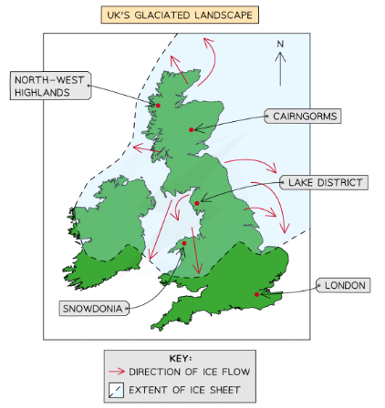
By the Quaternary, glaciers covered the middle and north of Britain, shaping the landscape we see today. The first humans occupied Britain during the Quaternary.
The most recent glacial period in UK stretched from 100-12 Ka. I’ve found various descriptions of its southerly extent, but am not sure which, if any, are definitive. All agree, however, that the region of southwest England where we are walking was not glaciated, but that its geomorphology is shaped by periglacial influences, including intense freeze-thaw weathering (e.g. Dartmoor tors), and sediment deposits due to glacial meltwater flooding.
I believe these were mostly formed during the Variscan orogeny; transform faults (not shown) were formed later
History vis a vis Rock Types
[Extracted from material produced by Perplexity (ChatGPT); Other Sources]
Precambrian to Paleozoic Eras
Tectonic, orogenic and magmatic events; some erosion and deposition
>540 Ma (Precambrian): Formation of mafic and ultramafic rocks of Lizard Peninsula ophiolite
~540 – 420 Missing rocks / unconformity () – but present in Wales
420-359 Ma (Devonian ): The Old Red Sandstone, found in areas like Portishead, North Somerset, and the Morte Slates in North Devon
430-300 Ma: Variscan Orogeny, and uplift of the Lizard Peninsulaophiolite
(359-299 Ma (Carboniferous): Carboniferous Limestone (Mendip Hills, Somerset feature; BurringtonOolite)
~289 Ma: Intrusion of Cornubian batholith, and metamorphism of older sedimentary rocks
Mesozoic Era
Often covered by shallow seas and fluvial environments leading to sedimentary deposition
Triassic (252-201): Red and grey mudstones ( Mercia Mudstone and Penarth Groups), visible at Aust Cliff along the Severn Estuary.
Jurassic (202-145): Jurassic Coast features a sequence of rock formations from the Triassic, Jurassic, and Cretaceous periods.
Cretaceous (145-66): The chalk formations (e.g. Old Harry Rocks near Swanage).
Cenozoic Era
Uplift and erosion, and also various forms of marine and fluvial environments.
Paleogene and Neogene (66-2.5 Ma): Sediments (Branksome Sand Formation in Poole Harbour) laid down in swamp, estuary, or delta settings
Quaternary Period
Erosion, periglacial-weathering
The Quaternary period, (2 Ma to present), has had significant climatic fluctuations (glaciation; periglacial effects; sea level change) that have shaped the landscape of Southwest England as it is today
Dorset
[From Wikipedia, Dorset]
Geography of Dorset
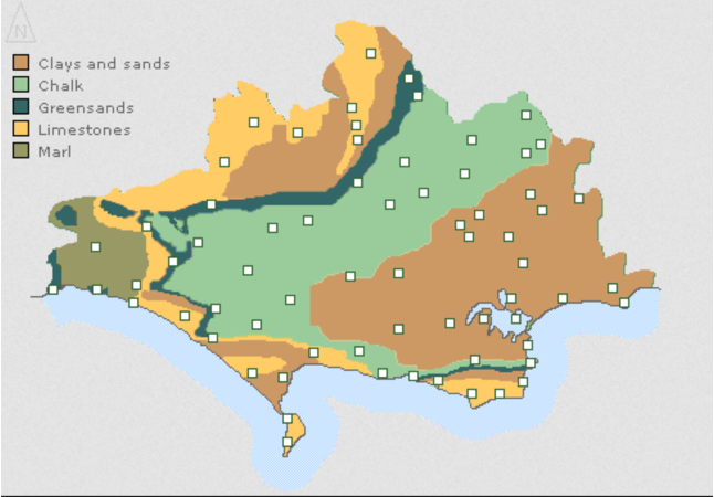
Dorset has a varied landscape of chalk downs, steep limestone ridges, and low-lying clay valleys. The majority of its coastline is part of the Jurassic Coast World Heritage Site due to its geological and palaeontologic significance, and features notable landforms such as Lulworth Cove, the Isle of Portland, Chesil Beach and Durdle Door. The north of the county contains part of Cranbourne Chase, a chalk downland. [Wikipedia, Dorset]
Geology of Dorset
Dorset contains considerable variety in its underlying geology, which is partly responsible for the diversity of landscape. A large percentage (66%) of the county comprises either chalk, clay or mixed sand and gravels. The remainder includes Portland and Purbeck stone, other limestones, calcareous clays and shales.
Dorset has a number of limestone ridges which are mostly covered in either arable fields or calcareous grassland supporting sheep. These limestone areas include a wide NE-SW band of Cretaceous chalk which crosses the county as a range of hills f incorporating Cranborne Chase and the Dorset Downs, and a narrow band running from south-west to south-east, incorporating the Purbeck Hills. Between the chalk hills are large, wide vales and wide flood plains.
West. In the far west of the county and along the coast there are frequent changes in rock strata, which appear in a less obviously sequential way compared to the landscapes of the chalk and the heath. In the west this results in a hilly landscape of diverse character that resembles that of neighboring county Devon.
East (Jurassic) Coast. All of the principal rock types of the Mesozoic can be seen on the Jurassic Coast of Dorset and East Devon, where they document the entire era from west to east.
The central parts of Dorset are dominated by an extensive swathe of chalk running North East to South West and through the South of the County round Weymouth to Purbeck. It extends North East towards Salisbury Plain in Wiltshire. It is an elevated, spacious landscape with a prominent escarpment which dominates and defines the undulating farmlands to the North, West and South of the county.
The shallow dip slope of the chalk borders the heathland landscapes of the Poole Basin. This undulating lowland contains the remnants of a once extensive area of heathland; Hardy’s Egdon Heath and is based on thin and impoverished sands and gravels. It is drained by the alluvial basins of the Frome, Piddle, Stour and Avon, four of Dorset’s main rivers which flow out to sea through extensive stretches of pasture, marsh and mudflats associated with Poole and Christchurch harbours.
[…]
To the West of the county the landscape is more varied reflecting the complex geology, with steep distinctive greensand ridges separating clusters of deeply incised valleys and broad rolling farmland. In the middle of West Dorset, the Marshwood Vale, formed on the marls of the Lower Lias, is a secluded, bowl shaped depression, almost hidden by the surrounding complex landforms. These landforms include the broad arc of heathy greensand ridges and some of the highest points in the county…
The lowlands to the West and east of Weymouth are different again to the West Dorset landscapes. A series of broad, hogback shaped limestone ridges alternate with spacious shallow clay valleys. The landforms all follow an east-West alignment and the landscape has a steady consistent rhythm. This ‘ridge and vale’ landscape flows down to the quiet edges of the brackish Fleet lagoon contrasting with the more exposed seaward side of this distinctive feature which is separated from the sea by the sweep of Chesil Beach. This distinctive shingle bank links the rocky limestone peninsula of Portland to the mainland.
The far South eastern corner of the county has a unique and remarkable geological context. The Isle of Purbeck is renowned for the variety and structural clarity of its rocks and landforms. A high chalk ridge, which once linked Purbeck to the Isle of Wight, separates the heathlands of the Poole Basin from the secluded clay valley of the River Corfe to the South. A further ridge and distinctive plateau, this time of limestone, separates this valley from the sea.
…When the sea rose following the ice age leading to the severance of the chalk ridge joining the Isle of Purbeck to the Isle of Wight and the flooding of the upper reaches of the Solent River to form Poole harbour. The chalk stacks of Old Harry Rocks to the East of Ballard Point are the remnants of former chalk ridge which linked the Isle of Wight.
Visible Features in Dorset
@Chesil Beach
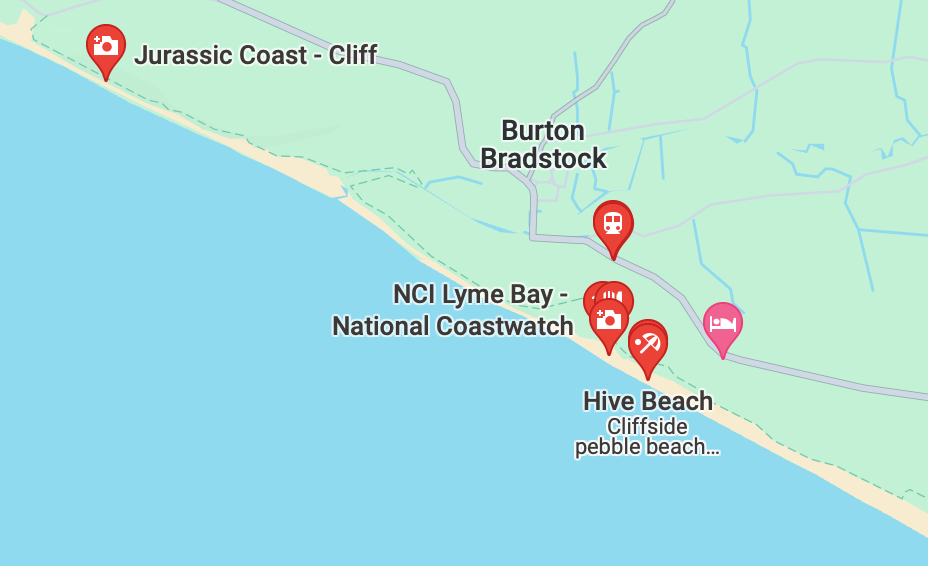
Further south at Chickerell Hive Point there are exposures of Oxford Clay. Here the clay splits into thin layers along the bedding planes and form what is known as a shale. This clay was exploited in the past at Crookhill brickworks. The manufacture of bricks ceased in 1969. This part of the rock succession is organic rich and this helped in the firing of the bricks. Fossils found include the ammonite Kosmoceras (Picture 11) as well as small bivalves. The shape seen is an impression of the shell, the shell itself has been lost through geological processes.
Another feature of the Oxford Clay south of Chickerell Hive Point is large concretions called septarian nodules (Picture 12). These formed in the sediment below the sea floor and are made of calcium carbonate. When pure it forms white crystals of calcite, a polymorph of calcium carbonate. The concretions can be up to a metre across and are left weathered out on the beach because they are stronger than the clay. Examples of septarian nodules can be seen in Portland Museum.
At Tidmoor Point south of Chickerell Hive there are more exposures of Oxford Clay where pyritised ammonites, especially Quenstedtoceras (Picture 13) can be found as well as small belemnites and crinoid fragments (ossicles). The clay slumps onto the beach and wave action washes out the fossils.
@Abbotsbury
These ancient landslide slopes can be seen around the edge of the Marshwood Vale (Sliding Hill at Bettiscombe is a good example), on the western side of Quarr Hill, Chideock below the Bellstone on Eggerdon and both sides of Abbotsbury Hill Fort.
@Quantock Hills
The Quantock Hills are largely formed by rocks of the Devonian period, which consist of sediments originally laid down under a shallow sea and slowly compressed into solid rock. In the higher north-western areas older Early Devonian rocks known as Hangman Grits (or, more formally, the Hangman Sandstone Formation).
Hangman Sandstones (upper to lower):
sandstone and conglomerate (Hodders Combe Beds )
green sandstone and mudstones (Triscombe Beds) .
siltstones and slates ( Little Quantock Beds)
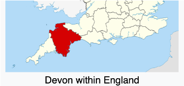
Devon
[from Wikipedia, Devon]
Devon Geography
Devon has a varied geography. It contains Dartmoor and part of Exmoor, two upland moors which are the source of most of the county’s rivers, including the Taw, Dart, and Exe. The longest river in the county is the Tamar, which forms most of the border with Cornwall and rises in the Devon’s northwest hills. The southeast coast is part of the Jurassic Coast World Heritage Site, and characterized by tall cliffs which reveal the Triassic, Jurassic and Cretaceous geology of the region. The county gives its name to the Devonian geologic period, which includes the slates and sandstones of the north coast.
Devon Geology
[ Possibly from “The Geology of Dartmoor.”] and [From Wikipedia, South West England]
Geologically the region is divided into the largely igneous and metamorphic west and sedimentary east, the dividing line slightly to the west of the River Exe.
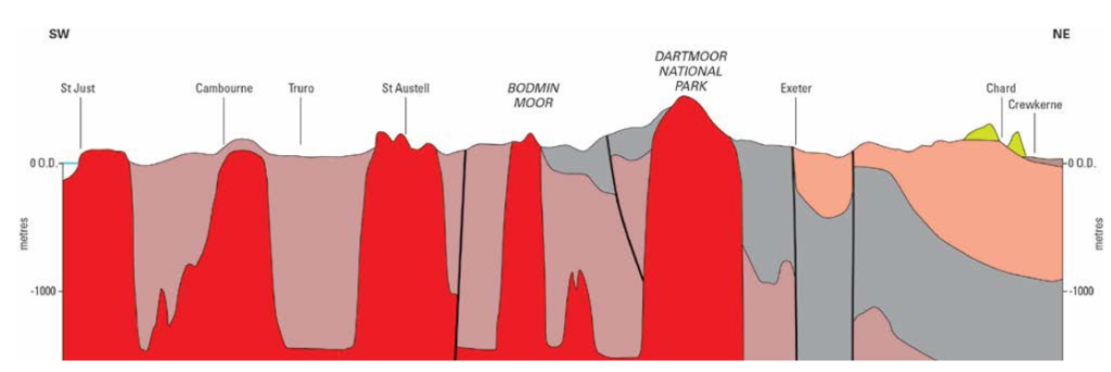
West. Cornwall and West Devon’s landscape is of rocky coastline and high moorland, notably at Bodmin Moor and Dartmoor. These are due to the granite and slate that underlie the area. In North Devon the slates of the west and limestones of the east meet at Exmoor National Park.
East. The east of the region is characterized by wide, flat clay vales, and chalk and limestone downland. The vales, with good irrigation, are home to the region’s dairy agriculture. The Blackmore Vale was Thomas Hardy’s “Vale of the Little Dairies.” The Southern England Chalk Formation extends into the region, creating a series of high, sparsely populated and archaeologically rich downs, most famously Salisbury Plain, but also Cranborne Chase, the Dorset Downs and the Purbeck Hills. These downs are the principal area of arable agriculture in the region. Limestone is also found in the region, at the Cotswolds, Quantock Hills and Mendip Hills, where they support sheep farming.The sedimentary rocks of Devon are primarily of shallow-water marine origin, and include mudstones, sandstones and limestones. There are also metamorphic rocks resulting from high temperature/high pressure tectonics, and, around Dartmoor, high temperature/low pressure contact metamorphism.
“The rocks of the Devonian period in Devon are all of marine origin, but are not necessarily the deposits of a deep sea. Thus, the Devonianlimestones of South Devon, Plymouth, Yealmpton, Ashburton, Newton Abbot and Torquay, are fossil coral reefs, and there is no soundreason for the supposition that the species of coral which built those reefs were capable of living and growing at any greater depth belowthe surface than can the species now living. At a generous estimate this would give a depth of forty fathoms to the waters in which the reefsoriginated. No similar approximation can be given to the Emit of depth at which the rocks known as ‘ grits’ have been formed, but sandstones of any sort are not consistent with deep-sea beds.”
Surface Geology of Devon
Dartmoor National Park
Dartmoor National Park is centered around a 625 K2 area of granitic pluton intruded into older Devonian and Carboniferous sedimentary rock (shales, sandstones, and limestones) about 280 Ma; the pluton is part of the Cornubian batholith that underlies much of southwest England. Around the margins of the granite, these sedimentary rocks were altered by thermal metamorphism into hornfels (hard, fine-equigranular, HT/LP rock that preserves some of the textural characteristics of the protoliths, but lacks foliation due to lack of pressure during metamorphism).
Dartmoor Tors
[Source: Unsure… partly Wikipedia]
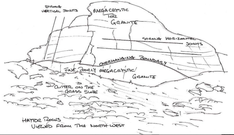
Dartmoor is noted for its tors (Welsch for cluster or heap), low granitic rock formations resulting from freeze-thaw weathering.
The tors of Dartmoor have a castellated form, controlled by closely spaced vertical jointing, as well as (sometimes) horizontal jointing. Most Dartmoor tors are less than 100,000 years old, having emerged at the start of the last major glaciation, no doubt as a result of freeze-thaw weathering.
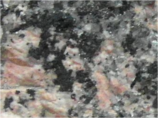
Most tors are composed of megacrystic granite with orthoclase tablets up to 5 cm in length. At lower elevations, the granite is more finely-grained and has few or no megacrysts.
Also see this lovely map of the tors of Dartmoor that Charlie found. It appears to be a work of obsessive enthusiasm, though, oddly it does not give any information about the rock itself. See: https://www.torsofdartmoor.co.uk/map.php. Be sure to follow the link under the name of each tor.
The megacrystic granite found at higher elevations contains large orthoclase feldspar phenocrysts 7 cm long, which indicates very slow cooling of the granite magma in the roof zone of the pluton. (But I don’t understand why that would allow the formation of megacrysta. Perhaps, if it were very deep, it may be that orthoclase crystals are less dense than the magma, and floated towards the top of the chamber (that happens with plagioclase, but I don’t know if it happens with orthoclase). The orthoclase concentration may indicate assimilation of country rock which increased the potassium content and thus the orthoclase (relative to the plagioclase). This granite is also dominated by biotite, in contrast to the finer-grained lower elevation (‘blue’) granite which has more muscovite.
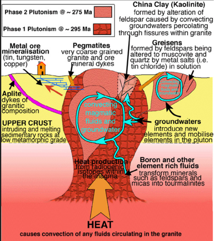
In general, Dartmoor granite is characterized by a relatively high proportion of tourmaline (a boron-bearing mineral) which suggests the granite magma had a mantle component.
“Tourmaline is commonly recognised in the field in Devon and Cornwall, as though it was a single mineral. In fact “tourmaline” is a group of 11 minerals. The common black (in field appearance) mineral is southwest England is probably mostly schorl, but this is generally referred to in the local literature as tourmaline, and is not often analysed. Microscopically the colour of the tourmaline may be blue or brown but this may not be seen in the field; it is just the very dark colour that is obvious. In composition it is a complex boron and aluminium silicate with some iron (or magnesium etc). The interesting aspect is the presence of boron. The origin of the boron is a topic of special interest.
“Tourmaline belongs to the trigonal crystal system and has a hardness of 7 to 7.5 (i.e. it is hard like quartz and cannot be scratched with a knife). Its very dark colour and vitreous lustre is distinctive in the area of the granites of southwest England. It often shows crystal faces. It is extremely common, particularly in faults and fissures and often found with quartz, producing black and white veins. It is generally one of the most common late vein minerals associated with the granites. It is frequently seen in the field and is not valuable (valuable, coloured varieties do exist, but not usually here).
“In the Castle Drogo area pebbles or cobbles consisting of quartz and tourmaline veins are easily seen in the banks of the River Teign. The dark vitreous mineral should not be mistaken for the tin ore – cassiterite, which is much more difficult to find.
“Because tourmaline is a constituent of veins in the Dartmoor granite it is usually a late product. The granite emplaced about 298 million years ago, had cooled sufficiently to fracture in a brittle manner. Perhaps the granite was down to only 250 or 300 degrees C.
“However, it certain cases the tourmaline is found more dispersed within the granite, rather than just in veins. A rock with dispersed acicular “suns” of black tourmaline is know as Luxullianite. It takes its name from Luxulyan near St. Austell. This rock type is apparently the result of metasomatic replacement of granite in situ, according to Lister (1978) (and not from the emplacement within the granite batholith of a late stage boron-rich magma).”
Cornwall
Cornwall Geography
[From Wikipedia, Cornwall: quoted verbatim or lightly paraphrased]
Cornwall is characterized by steep cliffs and, to the south, several rias [drowned river valleys], including those at the mouths of the rivers Fal and Fowey. It includes the southernmost point on Great Britain, Lizard Point, and forms a large part of the Cornwall National Landscape. The national landscape also includes Bodmin Moor, an upland outcrop of the Cornubian batholith granite formation. The county contains many short rivers; the longest is the Tamar, which forms the border with Devon.
The north and south coasts have different characteristics.
The north coast is more exposed and therefore has a wilder nature. The High Cliff, between Boscastle and St Gennys, is the highest sheer-drop cliff in Cornwall at 732 feet.
The south coast is more sheltered and has several broad estuaries offering safe anchorages, such as at Falmouth and Fowey. Beaches on the south coast usually consist of coarser sand and shingle, interspersed with rocky sections of wave-cut platform.
The interior of the county consists of a roughly east–west spine of infertile and exposed upland, with a series of granite intrusions, such as Bodmin Moor, which contains the highest land within Cornwall. From east to west, and with approximately descending altitude, these are Bodmin Moor, Hensbarrow north of St Austell, Carnmenellis to the south of Camborne, and the Penwith or Land’s End peninsula.
Cornwall Geology
[From Wikipedia, Cornwall: quoted verbatim or lightly paraphrased]
The granitic intrusions in the interior are the central part of the granite outcrops that form the exposed parts of the Cornubian batholith of south-west Britain, which also includes Dartmoor to the east in Devon and the Isles of Scilly to the west, the latter now being partially submerged.
The intrusion of the granite into the surrounding sedimentary rocks gave rise to extensive metamorphism and mineralisation, and this led to Cornwall being one of the most important mining areas in Europe until the early 20th century. It is thought tin was mined here as early as the Bronze Age, and copper, lead, zinc and silver have all been mined in Cornwall. Alteration of the granite also gave rise to extensive deposits of China Clay, especially in the area to the north of St Austell, and the extraction of this remains an important industry.
The uplands are surrounded by more fertile, mainly pastoral farmland that lies mainly on Devonian sandstone and slate. The north east of Cornwall lies on Carboniferous rocks known as the Culm Measures. In places these have been subjected to severe folding, as can be seen on the north coast near Crackington Haven and in several other locations.
The geology of the Lizard peninsula is unusual, in that it is mainland Britain’s only example of an ophiolite. Much of the peninsula consists of the dark green and red Precambrian serpentinite, which forms spectacular cliffs, notably at Kynance Cove, and carved and polished serpentine ornaments are sold in local gift shops. This ultramafic rock also forms a very infertile soil [similar to Ring Mountain Preserve in Marin County] which covers the flat and marshy heaths of the interior of the peninsula. This is home to rare plants, such as the Cornish Heath, which has been adopted as the county flower.
On the Variscan Orogeny
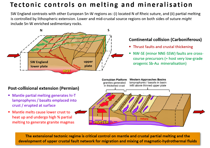
[From “The Geology of Cornwall,” whose source I have misplaced]
The peninsula of Cornwall has a geological character distinct from t the rest of the UK. It represents the eroded basement of a Palaeozoic Mountain Belt formed by the Variscan Orogeny (300 – 275 Ma, late Carboniferous – Permian)., with the S-type granites so indicative of mountain building processes, and shows many features associated with mountain building processes: compressional structures, thrust faults and folds, the remnants of a closed ocean (the Lizard Ultramafic Complex), a low grade regional metamorphism. and the intrusion of the aforementioned granites which produced contact metamorphic aureoles and abundant mineralisation.
Mineralization and Alteration of Cornubian Granites
The Keweenaw Fault is a ~100 mile reverse fault that bisects the Keweenaw Peninsula of the Upper Peninsula of Michigan and marks the boundary between the Mid-continent rift and continental rocks. The fault is a reverse fault that thrusts lava flows of the Midcontinent Rift System onto sedimentary rocks of the Jacobsville Sandstone, and is part of the inversion of the Midcontinent Rift where a region that had previously undergone extension experienced significant contraction during the final stages of the Grenville orogeny. There are few (no) surface indications of the fault; but the Pilgrim river runs along the sandstone side of the fault trace.
*A Wilder Time: Notes from a Geologist at the Edge of the Greenland Ice. William E. Grassley, 2018.
A lyrical book that provides an account of a geologic expedition to gather evidence for a 1.8 Ga collision between continents that resulted in a series of shear zones in western Greenland. Also important for providing evidence that plate tectonics has been going on for a long time, something that has been contested. Content is quite interesting, but I also appreciate it for its lyrical writing about landscape and geology, which is this focus of my “LS” project.
Over the last couple of years I’ve become aware of a new way in which I learn things. It is a sort of consolidative learning.
Since I’ve retired, one of my activities has been to learn about geology. That mostly involved taking classes or reading books; occasionally it happens via going on field trips, but those are pretty few and far between. But, over the last few years, I’ve become of a new way I learn things – or perhaps it is better to say consolidate what I already know, or connect the dots…
Geology Subs
It involves reddit, which I visit nearly every morning, in response to the daily email that alerts me to new activities in the subs I follow. These are primarily geology-oriented subs like “whatsthisrock” “askgeology,” and “rockhounds.” Initially I visited because I wanted to get better at identifying field specimens of minerals, and identification requests, and the ensuing discussion, make up a significant portion of the content. After a while, I began weighing in on the debates, and came to recognize areas – such as mafic igeneous rocks – where I had something to contribute.
This book was recommended in Kim Stanley Robinson’s The High Sierra: A Love Story, as a good guide to the ecology and botany of the Sierra Nevada (and the upper portions of other North American ranges). And, indeed, it is beautifully written with a narrative style in which the reader moves through landscapes with the authors, looking at this and that, in contrast to what I had expected would be more of a catalog or encyclopedic approach. The book is divided into two principle parts: part 1 examines elements of ‘above the trees’ ecosystems, like fellfields or krumholtz; part 2 looks at particular North American tundra ecosystems, with one chapter being on the Sierra Nevada.
The High Sierra: A Love Story, by Kim Stanely Robinson. 2022.
* I was reading this for other reasons, but nevertheless it fits well into my project to read essays that focus on landscape and natural history.
TL;DR: I love this book. But it is not for everyone. On the other hand, it is organized in such a way that readers interested in particular topics — geology, history, etc. – could skip through the book attending to one or a few themes that interest them. It has great pictures, too.
#
I’m a big fan of KSR, and think it likely that I’ve read everything he’s written, although it is possible that that omits a few early science fiction novels that were retroactively published after he became better known. I like the complex characters he develops, the intensely developed worlds he portrays, and especially his attention to geology, climate, economics, politics, and the role of large institutions – themes that are uncommon in much science fiction. Also unusual is that he sometimes ventures beyond the borders of SF, as with his novel Years of Rice and Salt, and especially with this book, which is multi-threaded work the interweaves memoir, geology, natural history and history.
Notes on where I think the various essays I’ve produced are. This is unlikely to be of interest to others.
Status of Essays
1. Napkin Thief. Unsure. It is a fun story, but not much substance. Not sure what to do.
2+6 A Straight Transect. Nearly done.
3. Mind in the Hand. Final.
4. Body and Mind. Mostly done. Replace lime tree section with exercise at home — retitle as PT. –> I am partway through replacing the lime tree section, but the new section seems a bit boring.
5. Aloha. Unsure. It is a fun story, but not much substance. Not sure what to do.
7. Why I like Hiking. Mostly done. Alter ‘crystal rain’ section. Bring in more Muir
* Reading with CJS. Page numbers cited are from Annals of the Former World, a collection of his work of which Assembling California is only one part. The parts of the AC, as described below, are not well-separated in the text; they only appear in the table of contents.
These are my notes on Oaxaca Journal, by Oliver Sacks, 2019. This is part 8 of the course of essay reading I am doing with CT; in particular, this is part of what we have dubbed ‘The Summer of Sacks.’ Strictly speaking, these are not essays but rather chapters — or daily entries – from a journal he kept of a trip to Oaxaca, Mexico, with the American Fern Society.
Introduction
Sacks opens by writing of his love of the Natural History journals of the nineteenth century, and their blend of the personal and professional. He notes that most of the naturalists were essentially amateurs, self-taught, and feeling their way before or as biology and botany were crystalizing into sciences. He adds:
This sweet, unspoiled, preprofessional atmosphere, ruled by a sense of adventure and wonder rather than by egotism and a lust for priority and fame, still survives here and there, it seems to me, in certain natural history societies, and amateur societies of astronomers and archaeologists, whose quiet yet essential existences are virtually unknown to the public. It was the sense of such an atmosphere that drew me to the American Fern Society in the first place, that incited me to go with them on their fern-tour to Oaxaca early in 2000.
I attended the Institute of Lake Superior Geology meeting from April 23 to 26, 2023. I provide a brief description of the field trips in my Journal blog entry for May 1. These are notes I made during (and sometimes but not always about) the conference talks.
The conference papers were, for me, something of a mixed bag. Some were a bit too abstruse for me to follow, some ventured in to extreme detail on subjects I didn’t care so much about, but others introduced me to interesting comments, or provided provocative perspectives on what I had imagined were settled matters.
The Ends of the World: Volcanic Apocalypses, Lethal Oceans, and our Quest to Understand Earth’s Past Mass Extinctions. Peter Brannon. 2017
April – June 2023
Summary of Periods and Mass Extinctions
Edicarian: 635-538. First appearance of wide-spread multi-cellular organisms in ocean: Soft-bodied microbial organisms forming mats and other structures, and free-floating filter feeders.
End-Edicarian extinction: ~448. 86% species went extinct.* Possibly due to advent of burrowing organisms that disrupted largely sessile ecosystem. Not an official mass extinction because of a very incomplete fossil record.
Cambrian: 538-485. Warm shallow seas flank margins of several continental remnants of the breakup of the supercontinent Pannotia. In ocean there is the advent of hard-bodied complex organisms, and subsequent explosion of diversity into all phyla known today. The land bare except for microbial crust; arthropods and mollusks begin to adapt to life on land towards the end of this period.
Ordovician: 485 – 433. High CO2 levels and continents inundated with vast shallow seas jammed with life: brachiopods; trilobites; cephalopods; eurypterids; grapholites; and jawless fish. Many isolated continents and islands, with continents at south pole and a global sea occupying most of the northern hemisphere. First spores of land plants (fungi and simple plants) at 467Ma, with their spread possibly releasing phosphorous into the ocean stimulating algal blooms and CO2 sequestration.
End-Ordovician extinction:~345 Ma. 75% species went extinct.* Major ice age, likely precipitated by biogenic CO2 depletion, followed by a whip-lash of warming.
Silurian: 443-419. Gondwanaland and island chains provide diversity of environments; in the ocean early fish diversify into jawed and bony fish. Terrestrial life expands in the Silurian-Devonian Terrestrial Revolution: vascular plants emerge from more primitive land plants, and three groups of arthropods (myriapods, arachnids and hexapods) became fully terrestrialized.
Devonian: 419-359. Gondwana supercontinent in the south, Siberia to the north, and Laurussia to the east. Free-sporing vascular plants form extensive forests (Archaeopteris); by the middle of the Devonian several groups have evolved leaves and true roots; by the end the first seed-bearing plants appear.
Late-Devonian extinction event: ~250 Ma. 96% species went extinct.* Two major extinction pulses, and many smaller pulses. One theory is that it is due to the release of nutrients by the punctuated spread of land plants as they developed vascular systems with leaves and roots, and seeds.
Carboniferous: 359-299. Age of amphibians — also first appearance of amniotes from which both reptiles and mammals came. Vast rainforests covered the land, and insects diversified. The latter part of the Carboniferous experienced glaciations, low sea level, and mountain building as the continents collided to form Pangaea. A minor marine and terrestrial extinction event, the Carboniferous rainforest collapse, occurred at the end of the period, caused by climate change
Permian: 299-251. On land: The Carboniferous rainforest collapse left behind vast regions of desert in the continental interior. Amniotes, which could better cope with the conditions, diversified into the synapsids (the ancestors of mammals which came to dominate the Permian) and the sauropsids (reptiles). . In the ocean fish diversify with placoderms dominating almost every known aquatic environment, alongside coeleocanths, with sharks and bony fishes on the sidelines.
End-Permian extinction: 251.9 Ma. 80% of species went extinct.* The Siberian Traps were created at 252 Ma and also interacted with the Tunguska sedimentary basin filled with carbonates, shale, coal and salt in layers up to 12 Km thick; it is the worlds largest coal basin. When the magma intersected the basin, it caught fire, detonated in multiple places, and released vast about of CO2 and methane, on top of the CO2 produced by the eruption contributing to global warming and ocean acidification and anoxia. Other chemicals produced by the incineration of the Tunguska basin contents may have destroyed the ozone layer.
Triassic: 252-201. Brannen argues for a long 5 – 10 million year recovery, but that is disputed. The ancestors of crodcodiles dominated the Triassic; ancestors of dinosaurs and first true mammals appear, but were not dominant. The global climate during the Triassic was mostly hot and dry. Pangea had deserts spanning much of its interior until ita began to gradually rift into Laurasia and Gondwana to the south. In line with this the climate shifted from hot and dry to more humid, with a massive rainfall event called the Carnian Pluvial Event that lasted a million years.
End Triassic Extinction: 200 Ma. 80% of species went extinct.* Volcanism from the rifting of Pangea produced flood basalt that covered more than 4 million square miles. The CO2 concentration doubled or tripled, raising the already warm temperatures by at least 3 ° C. The final extinction pulse was fast: on the order of 20,000 years.
Jurassic: 201.4 – 145. Gondwana begins to rift. Climate warm and humid.
Cretaceous: 145 – 66. Gondwana completes rifting and by the end of the period today’s continents are recognizable, but with shallow inland seas in North America and Africa and between Greenland and Norway.
End Cretaceous Extinction: xxx. 76% of species went extinct.* Most likely some combination of the eruption of the Siberian Traps and the Chixtulub impact lead to global warming and an extended period of darkness. Almost all large animals eliminated, including all dinosaurs excerpt ancestors of birds.
Percent of species that went extinct, for any one event, vary considerably among sources. These numbers are better read as an indicator of relative severity.